
 home
home
 gallery
 contact
 About Us
 Services
 Alexandria Homemove


Free Estimates
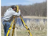
Nyberg Surveying offers free estimates for all your surveying needs.
Boundary Surveys
A boundary survey determines the property lines of a parcel of land described in a deed. A boundary survey may be required for various reasons.Read More
Topographic Surveys
A topographic survey is used to show the location and elevations of the various improvements and features over a tract of land.Read More
Impervious Area Surveys
Impervious area surveys are used to determine the percentage of impervious surfaces on a parcel.Read More
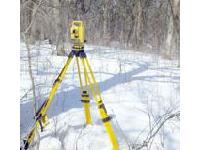
GPS Surveys
A Global Positioning System is utilized to gather large amounts of horizontal and vertical data across relatively large areas. Nyberg Surveying uses the Global Positioning Systems (GPS) for most of our surveys.
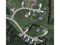
Land Planning and Subdivision Design
Nyberg Surveying can assist you with the process of land planning or dividing a large tract of land into smaller lots or units.Read More
Minor Subdivisions
Minor subdivisions are usually 1 or 2 lot subdivisions that oftentimes only require a boundary survey and a legal description of the portions to be divided.Read More
ALTA / ACSM Land Title Surveys
ALTA/ACSM Land Title Survey is a specialized boundary survey that meets specific needs for land title insurance purposes. An ALTA survey discloses all survey-related title issues so that lending institutions, title attorneys, and/or purchasers can make informed decisions about a piece of real estate.Read More
FEMA Elevation Certificates
An elevation certificate is a document prepared by a surveyor that is used to determine if a piece of property or a structure lies within a floodplain.Read More
Building Permit Surveys
Building permit surveys are required in a number of counties and municipalities prior to new construction. Requirements on a building permit survey vary but usually include the parcels boundary, topographic conditions, and existing and proposed improvements.Read More
Condominiums and CIC Plats
A condominium is a form of real property where a specified piece of real estate, often times a portion of a building, is individually owned.Read More
Cemetery Layouts
Cemeteries in Minnesota are required to keep a plat map on file showing the layout and dimensions of burial plots. Nyberg Surveying has mapped both existing and proposed cemeteries to comply with these requirements.
Request a Free Quote from Nyberg Surveying
The more information you can provide, including a description of your project, will give us a better understanding of the service you need or feel free to give us a call.
